
Sooo, this adventure was tough…The plan was to walk from Albir to La Cruz. This was the Cross to which we walked from Benidorm last night only this time it’s about 8km and there is the minor inconvenience of the Sierra Helada standing in the way.
You’ll see from the map that there was a change of plan and it became a loop. It was a good idea at the time but became a little tense towards the end, oh…and a couple of times in the middle too!
Please click any of the pictures for a full size, full resolution view.

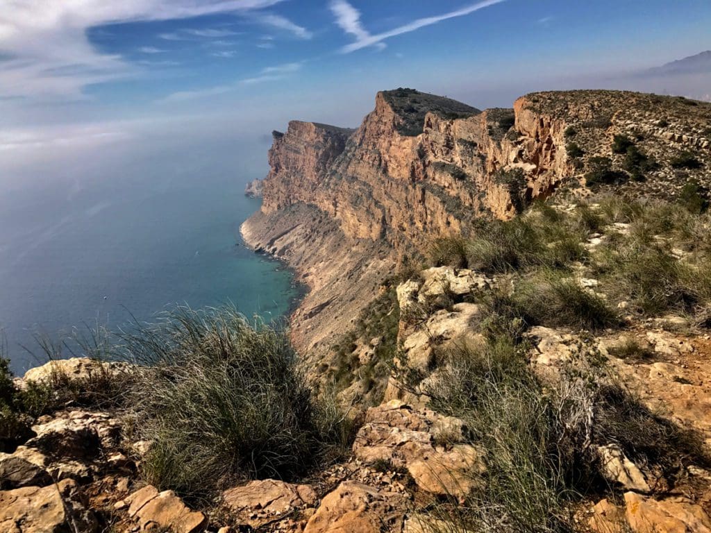
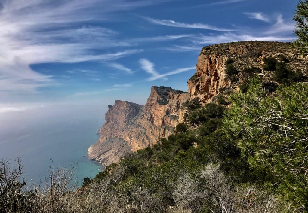
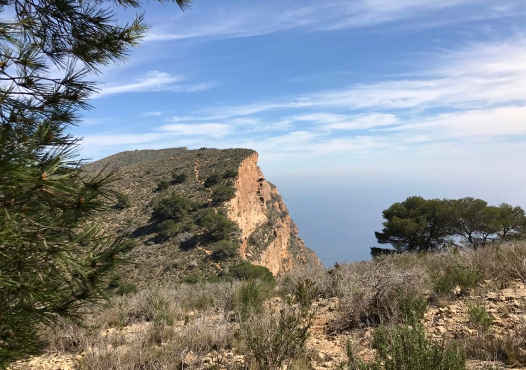
Sierra Halada literally means ‘Mountain Range (of) Frost’ although it rarely succumbs to sub-zero temperatures. The 1100 foot cliffs; however, are composed of calcite rocks and from a sailor’s perspective look just like ice especially in moonlight.
I have to say that I was keen until I looked at the height of some of the ‘hills’. I do this sort of thing ‘cos it helps me with my fear of heights but looking at the mini peak adjacent to La Cruz made me a little dizzy so I explained to The Pilgrim that I may have a minor problem with this one. The mini peak I’m looking at is just over 1000 feet (306m) and this is the smaller one that we’ll reach at the end of the walk! The big one at the start stands at just over 1400 feet (334m) and it’s seriously steep although the actual climb is closer to 1200 as we’ll park in a free car park at about 180 feet (50m).


We make a bit of an effort and rise at 07:30 with the intention of starting the walk at 0900. It doesn’t quite work out like that but we do eventually arrive at the car park at 0945 and after a quick use of the last toilet, we’ll see for 6 hours we’re on our way.
We have packed two and a half litres of water along with some clothes for if it’s cold. I’m feeling pleased that Boyes had a small and light rucksack that’s enabled us to include the above plus suncream and a sandwich. It was eight quid and has earned its cost by flying my cabin luggage in luxury with Thomsons Airline, it has to be as light as possible because their restriction is a measly 5km.
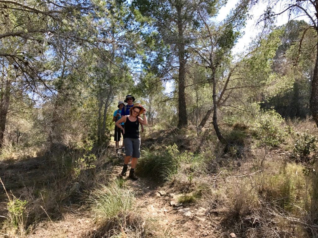
On the way up the first track, we meet Bob, a Canadian who lives here with his wife Jean. They spend six months on the Costa Blanca then six months in Nova Scotia, he runs a web site that illustrates walks on the Costa Blanca and their objective today is to recce one that they’d trekked some time ago. They’re accompanied by Peter, a retired lecturer, Pamela, his wife and Mike, an unbelievably fit individual who will later act as scout when we find a fence blocking the original track and potentiallyy creating a huge diversion.
The climb to the transmitter station is easy to extremely steep and includes negotiating huge rocks, loose scree, amazing routes and occasional bouts of dead easy path. I’m fit but the incline and terrain leave me sweating like a fat guy near a sweet factory. We’ve packed two and a half litres of water and I’ve pre-loaded with a good half litre so I should be peeing like a dray but I’m not so I do have a concern that it won’t be enough and this is reinforced when Bob asks us if the bottle that we’re drinking from is all we have and is reassured when we say we have another two bottles.
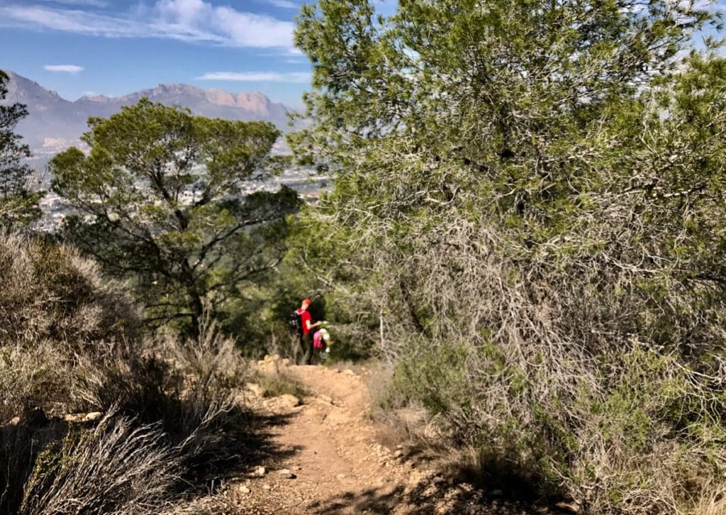
At the top, we stop to look at the view and discuss which of the two routes is appropriate. La Cruz is the winner and we begin the easy walk along the top on the asphalt road that connects the sewerage works to the transmitter station. Although we don’t know it yet, this going to be the easiest part of the route and enables unlimited views of the Puig Campana range of mountains including the huge notch that was kicked out by a giant and hurled into the Mediterranean just off Benidorm. The reason for this sudden and violent action was not borne in anger, it was an act of love to enable the sun to shine through to his wife who’d been off-colour and had been whinging about the lack of sun all day. That is one commodity that we’re not lacking and we’re both glad we’re wearing hats – regardless of what we look like.
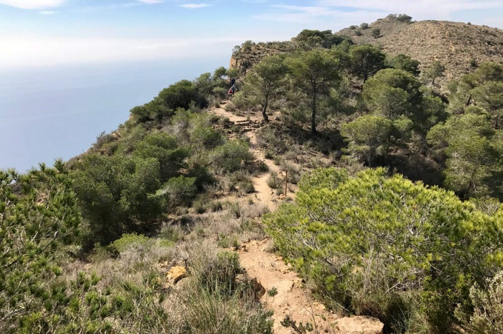
After about a kilometre we are directed off the asphalt and into the trees towards some serious looking cliffs. These are the cliffs that give this range its name and have fooled mariners for hundreds of years with their icy glow in the moonlight.
We duck and weave our way through pine trees as the track zigs and zags its way along the edge of the cliff then it turns inland but not far. As we walk together Bob tells us of his plan to walk to the peak just before the one that we’ve targeted and then turn off on to a ridge that will take them back down to where the cars are parked. It’ll take an hour or so, he says and is immediately contradicted by his wife Jean, “It’ll take a couple of hours”. She seems more switched on in terms of timing and he in terms of what to expect. They compromise at an hour and a half. This sets some thoughts off in my brain; if we go back with them then we don’t need to walk the asphalt road down into Benidorm that we’ve already walked last night and we’ll actually gain some time because we don’t need a taxi or bus to take us back to the car.
No sooner had these thoughts hatched than we’re on a ‘down’ bit, it’s nice but it is very rocky and I’m glad I brought my boots. I can see to the bottom of this gulley and the path meandering up the other side to the next peak. It’s still in light trees so there’ll be some protection from the sun but it is very steep and littered again with huge rocks.
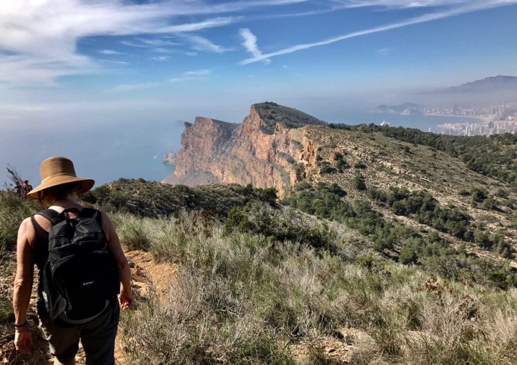
Towards the top, there’s a huge flat rock that The Pilgrim decides to stand upon and gaze out to sea making remarks about the different colours of the water reference to the depth. I can see her in silhouette and hear her observations but it’s making my toes curl knowing that these cliffs are seriously high and the water is splashing against them just over a 1000 feet below; oh, and she’s standing on the edge. I hear what she’s saying but I don’t take it in until she moves away from the rock and rejoins the track.
At the bottom of the gulley, we can see the incline to the next peak and it’s acute. Bob and Mike are off like mountain goats and the ladies together with Peter are following behind as we snake our way to the top. From here we can see several more of these peaks and gullies.
After another twenty minutes, Bob announces that the next down bit is into quite a deep gulley and is very acute, “It may mean there is to be some scrambling”, he says, “But…”, and then comes the reassurance, “…you can see the ground in front of you all the way down”.
So that’s alright then!
We arrive at the gulley and he’s right. The technique is to hold on to the rocks and slide your arse down but what he’d omitted to tell us is that it’s 90 feet (30m) to the bottom of the gulley – not that it matters really, my eyes are fixed on the next hand or foothold and ensuring it is stuck firmly to the ground. I must stress that we are not climbing (or more accurately descending) but it does raise my heart rate and in fairness to Bob he continues the reassurance, “…this is the only part like this”
I’m good with that!
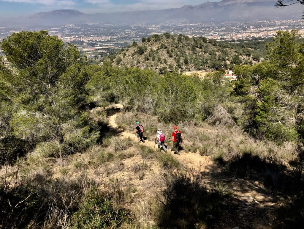
We’re now on our way up again and the terrain is even more rocky with some big steps to overcome some of the borders, to balance this there are parts where we’re walking along the contour and that enables us to get our breath back. At the top of this ridge, Bob calls a halt for lunch and they go to sit in the sun on the cliff whilst we take the opportunity to eat ours in the dappled shade of a pine bush sitting on rocks like pixies. It really is beautiful.
We make our way to the top of the cliffs where our new friends are still eating and I ask about the alternative way back so we don’t have to do the taxi bus stuff and it does sound like we’ll get back in about the same time as continuing down to Benidorm so after a brief discussion that’s what we’ll do.
The walk back is largely down along a ridge which gives us some excellent views of the range that we’ve just walked. The colours are impressive and so is the silhouetted outline of what we’ve just done.
We make good progress until we’re within about half an hour of the cars when we discover a new fence blocking our way and it’s a good six feet high. Bob goes one way whilst Mike tries another. The walk so far has taken it out of us and the thought of a backward trek up the way we’d come to find a new route was not what we wanted to hear. Jean is having a minor argument with Bob about where the path should be and in fairness she is right, we’re still 80 feet or so above them so we can see where it used to go but a significant chain-linked fence is now in the way.
Mike is now exploring what looks like the back of a half-built house and finds a way through an unlocked gate but it will mean that this part of the route will need to be re-drawn.
We’re feeling good now and start walking along an asphalted road past a ‘secret’ hotel where Madonna and various others stay when they come here for their R&R. It has a helipad on the top and various ‘facilities’ inside including a detox unit.
Turning right we find ourselves on some more ascent, we really could have done without this on the 13th kilometre but it’s a lot longer to go back. We’re led along some retaining walls that hold the land for cultivation or rather it used to be cultivated but now it’s strewn with rocks and stones making it difficult to negotiate.
A couple of more ‘ups’ and we pass a hunters hide (made from stones) and we’re on our way down joining the track that we used nearly 6 hours ago.
Thanks, Bob, Jean, Mike, Peter and Pamela, we’re really grateful for your company – but it was a stretch.
I love this job! G..x
Acknowledgement: Bob and Jean Hall at www.bobandjeanhall.com of Costa Blanca Mountain Walks for our company and the map.
If you enjoy reading these adventures please ‘like’ or ‘share’ using the buttons on the front page, it indicates to me what is popular and encourages me! …G..x
Discover more from Yorkshire Ramblings
Subscribe to get the latest posts sent to your email.
1 thought on “Albir to La Cruz – Benidorm”